Author: Osama S. M. Amin

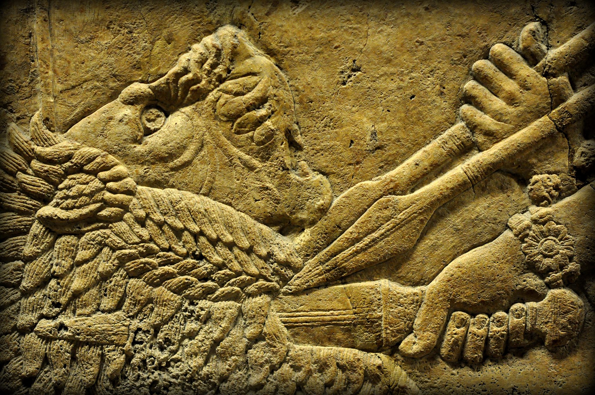
Assyrian Lion-Hunting at the British Museum

Whoever was privileged to gain access to the North Palace of the Assyrian king Ashurbanipal at Nineveh, could consider himself part of something timeless. Thanks to the great work of Hormuzd Rassam (1826-1910), who unveiled a large number of alabaster bas-reliefs, which once decorated the walls of that king’s Palace (built around 645 BCE); the Assyrian lion-hunting scenes! These extraordinary carvings, so dynamic and full of movements, are so realistic and so accomplished and are some of the most remarkable ancient artifacts ever found. They were discovered by Rassam in the year 1853 and have been housed in the British Museum since 1856. Rassam stated in his autobiography that “one division of the workmen, after 3-4 hours of hard labor, were rewarded by the grand discovery of a beautiful bas-relief in a perfect state of preservation”. Rassam ordered his men to dig a large hole in the mound; after more than 2,000 years, the remains of a royal palace were found. The mud-bricks had disappeared, of course, completely but the reliefs themselves, which once decorated them, …

Rock-reliefs of Mountain Merquli, Rabana and their near by settlements, Iraqi Kurdistan.

When you enter the main hall of the Sulaymaniyah Museum of Iraqi Kurdistan, you will encounter two large replicas of the rock-reliefs from the Mountains Merquli and Rabana. I was interested to know how to reach the originals and asked one of the Museum’s employees about it. He said they lie on two mountains outside the city of Sulaymaniyah and that you need someone to take you there because there are no clues on their precise location.

The Rock Relief of Harir (Hareer), Iraqi Kurdistan

Thursday, September 25, 2014 I was attending a neurology symposium in Erbil (Hawler), the capital of Iraqi Kurdistan. ِAfterwards, I headed to one of my relatives’ to pay him a visit; my family was with me. My relatives insisted we should stay in their home and spend a couple of days with them. And I thought, why not! At night, I surfed the net about rock reliefs in Iraqi Kurdistan and found one result that told of a relief in the village of Hareer called Rock Relief of Harir (Arabic: منحوتة حرير; Kurdish: نه خشي هه رير). I wondered what it was. I tried desperately to find any additional useful information about this relief, but I was unsuccessful! Friday, September 26, 2014 My relative, Dana Hiwa and I drove my car to the village of Hareer (or Harir; Arabic حرير; Kurdish هه رير). It was north to the city of Hawler about an hour and a half by car (36°33’48.47″N; 44°20’53.52″E). As there were no clues, I was not able to find the precise location of …

New Discovery: Unearthing a Neo-Assyrian Grave in Erbil, Iraq

An archaeologist friend of mine once told me: “Less than 5% of the Mesopotamian history has been found, and wherever you dig, anywhere in the land of Mesopotamia, you will discover something.” This story comes from Erbil (Hawler) Governorate. About 100-200 m away from the Citadel of Erbil (Arabic: قلعة أربيل; Kurdish: قه‌ڵای هه‌ولێر), an old house with a large garden was sold to an investment company. The company demolished the house and started to dig the foundation of a large building in late April 2015. In response to my questions, Architectural Engineer Sarbast Mahmood Ahmed replied: We were working 24/7. It was around 10 PM when we were digging the foundation of the building. The caterpillar excavator had reached 6 m in depth. Suddenly, one of the workers noticed that the machine had removed earth in addition to bricks. We stopped digging. After sunrise, we saw that we had unearthed what appeared to be a grave. Part of the grave was damaged while we were digging. Immediately, we informed the General Directorate of Antiquities. A …

New Discovery: Clay Tablet & Cylinder Seal from Tell Kunara, Iraq

On Thursday, October 1, I decided to pay Mr. Kamal Rashid, director of the General Directorate of Antiquities in Sulaymaniyah (GDAS), a short visit. He was thrilled and very happy to see me, “Osama have a seat…one of our French teams has just unearthed a clay tablet.” Rashid said. We were at the site of Tell (mound) Kunara (Arabic: تل كنارة; Kurdish: گردي كوناره). Tell Kunara (35°31’9.06″N; 45°21’35.07″E) was first documented in the 1940s. A survey was conducted by the General Directorate of Antiquities in Baghdad. According to the Archives Department of GDAS, Mr. Sabri Shukri visited, surveyed the location and wrote an official memorandum describing the site on November 10, 1943.

The Newly Discovered Tablet V of the Epic of Gilgamesh

I was taking photos in the main hall of the Sulaymaniyah Museum and came across a display case containing a small clay tablet. The description beside it said the tablet was part of the Epic of Gilgamesh and a fragment of tablet V. Immediately I thought it was a ‘replica’ as the description was superficial. It did not say the tablet was genuine, that it was newly discovered or even told about the many new pieces of information it had revealed. After the US-led invasion of Iraq and the dramatic looting of Iraqi and other museums, the Sulaymaniyah Museum (directed by the council of ministers of Iraqi Kurdistan) started an initiative. They paid smugglers to ‘intercept’ archeological artifacts on their journey to other countries. No questions were asked about who was selling the piece or where it came from. The Sulaymaniyah Museum believed this condition kept smugglers from selling their merchandise to other buyers, as they would have otherwise done so ‘with ease and without any legal consequences.’

The Secret History of Iddi-Sin’s Stela

Osama Shukir Mohammed Amin sets out on a detective journey to discover the mysterious history of Iddi-Sin’s stela in Iraqi Kurdistan. Going back into this region’s troubled past, he disentangles a family dispute and discovers what really happened to this exquisite artefact. I posted a picture on my personal Facebook page of what is commonly called “the rock of the Martyr Ghareeb Haladiny” (Kurdish: به ردي شه هيد غه ريب هه له ديني; Arabic: صخرة الشهيد غريب هلديني), which depicts a limestone stela of Iddi(n)-sin, king of Simurrum. Shortly after, one of my friends phoned me. He was very upset. He said that the “title” of the rock with respect to Martyr Ghareeb is wrong and that the rock was found by local people of the village of Qarachatan, and that Martyr Ghareeb had nothing to do with the rock. “They have altered the stela’s history and ignored the role of people of the village of Qarachatan, who found and protected this rock for 15 years,” he said. A few days later, I met with Mr. Hashim Hama …

Never Before Seen: The Belula Pass Rock Relief

I visited one of my relatives who resides at Lake Darbandikhan. It was a holiday. I was chatting with him about the relief of “Horen Shekhan” (Kurdish: هۆرێن و شێخان; Arabic هورين- شيخان) at Darband-i-Belula (Belula Pass). I told him that at the main hall of the Sulaymaniyah Museum, there is a large wall poster of a rock relief; the poster’s caption says that this is the “Relief of Belula Pass.” Where is this rock-relief of Belula Pass is located? He did not know the answer, but his son-in-law said that there is an ancient structure on a mountain at Darband-i-Belula (Kurdish: ده ربندي بيلوله) . “There is a sign on the road, I read it, which says that this the Akkadian relief of Belula Pass, but I have not seen that thing because it lies high up in the mountain,” he added. Fantastic! I said: “Can you take me there, please, at least I can start from there?” He agreed. This archaeological trip was entirely unplanned but I always take my Nikon gear with me wherever …

Visiting the Paikuli Tower Built by the Sasanian King Narseh

While I was photographing two large blocks at the main hall of the Sulaymaniyah Museum, I read that these blocks were part of the Sassanian tower of Paikuli. “Paikuli”(Arabic: بيكولي; Kurdish: په يكولي): a new name to me! I went home and surfed the net trying to find out what this tower represents. After getting the information, I phoned Mr. Hashim Hama Abdullah, the director of the museum. “Please, guide me on how to get there,” I asked him. He replied positively. It was a very sunny and hot day in mid-summer, and it was a holiday. I took a relative of mine, who resides near Lake Darbandikhan (Arabic: دربندخان; Kurdish ده ربنديخان), about 80 km south to the city of Sulaymaniyah. We drove south through Bani Khellan (Arabic: باني خيلان; Kurdish: باني خيلان) and then turned west to the foot of Paikuli pass to reach Barkal village (latitude 35° 5’53.91″N; longitude 45°35’25.95″E). The latter lies very near to the ruins of the Paikuli Tower. The ruins can be seen on a hill at the right side …

Finding the hidden Naram-Sin rock relief in Iraq

I was chatting with my uncle about the archaeological reliefs in the Governorate of Sulaymaniyah. The Governorate is part of Iraqi Kurdistan and is about 400 km north-west of Baghdad. He said that he saw a relief in the year 1985 on a top of a mountain, south-west of the city of Sulaymaniyah. The name of the relief, as the local villagers call it, is Naram-Sin (Arabic: نارام سين ; Kurdish: نيرام سن). This happens to also be the name Sargon the Great‘s grandson; Naram-Sin of Akkad (reigned 2261-2224 BCE). Interesting! Ok, let’s go. I drove my car and in about 2 hours, I reached the area my uncle had talked about (there is a road from the main street up to the top of the mountain, which was made by the local government). After that, I had to use my feet. From the top of the mountain, I descended down into a valley-like crevice. It is not that dangerous if you are familiar with hiking. Finally, there you are! The dead silence of the mountain top, together …